Guidelines for the definition of the general criteria on the use of DInSAR techniques for Civil Protection purposes
 The main project objective was to define Guidelines for the definition of the general criteria on the use of Differential SAR Interferometry (DInSAR) techniques for the development, implementation and management of remote monitoring networks of seismic and hydrogeological risks for Civil Protection purposes.
The definition of damage scenarios, after an earthquake or a landslide, through the use of remote observations and measurements, is a key requirement for the development of innovative systems for the monitoring of territory and infrastructures for Civil Protection purposes.
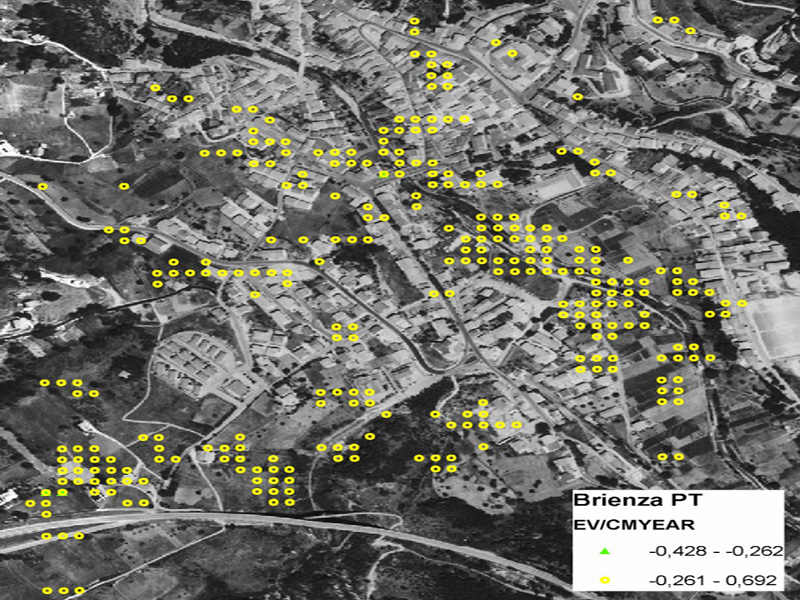
In this context, the common use of DInSAR techniques can contribute to significantly raise the diffusion of the Territorial Monitoring System, urbanized and not, allowing the accurate definition of damage scenarios, on a wide and detailed area, thanks to the enormous potentiality of the “remote observation” of Post Seismic – Permanent Residual Displacements of a very large number of survey points, Permanent Scatterers (PS), localized on the territory, buildings and infrastructures.
The specific project objectives were:
– Identification of the basic survey activities,
– Definition of the elements and procedures for the Synthetic Aperture Radar (SAR) data processing,
– Description of the features of the remaining resilient capability of the territory, buildings and infrastructures, compared to the evolutive space-time dynamics of territory,
– Definition of risk indicators,
– Definition of the general principles for the development and implementation of People Centered – Early Warning Systems (EWS-PC), as a decision support tool to support the Civil Protection.
Organismo scientifico di diritto pubblico per lo sviluppo socio-economico e lo studio dei rischi naturali, fondato sotto l’egida dell’UNESCO e della Regione Basilicata
Via Domenico Di Giura, 54 (Centro Direzionale), 85100 Potenza, Italy - Tel/Fax: +39 0971 69511 - CF: 80011410760